
The site around the so-called 'Mühlendamm' bridge which can be translated literally as 'Mills Dam' actually represents the city´s birthplace. In the beginning there was only a ford through the river Spree letting this place become an important part of long distance trade routes. People settled on both sides of the ford, the two neighbouring towns of Berlin and Cölln were born which later united.
The Mühlendamm as a structure was first mentioned in 1298. At the very beginning the inhabitants erected a bridge and later a wooden barrier which connected the two towns and dammed the water of the river. The widened river provided water for the ditches around the defence walls.
Starting from the year 1220 grain mills directly erected on the dam used the force of the water. Later on further mills for fulling (clothes production) and sawing (wood) came in addition. Their products were sold directly on the bridge in wooden stores and on two adjacent markets: On the Cölln side the Fish Market and on the Berlin side the 'Molkenmarkt'. The latter got its name from the mills on the bridge.
In terms of shipping the dam was a barrier: Ships had to stop and in order to continue the journey the goods had to be unloaded and to be carried to the other side of the dam. Then they were reloaded on other ships. But before reloading the traders had to act according to Berlin´s 'Stapelrecht' (engl.: staple right) which meant even if they just wanted to pass through the town they had to present their goods for a certain time at the local market. This also lead to more and more merchants permanently staying in Berlin and a growing economy. Meanwhile the first lock for ships was not mentioned until around 1550 being located in the nearby 'Cöllnischer Stadtgraben' (engl. literally translated: 'Cölln City Ditch'). From 1448 on the mills were owned by the the so-called 'Elector', the regent of Brandenburg (the region Berlin is located in). The 'mill master' working for the 'Elector' controlled the production of the goods as well as the thirlage (thirlage means the rule that nobody is allowed to bring their grain or other crude materials to another mill than the Elector´s one).
 |
| [P1]: The Mühlendammbrücke in 1680: The colonnades in the south and the mills in the north of the dam. Berlin on the right, Cölln on the left © Sascha Möllering/Berlin on Bike http://berlinonbike.de |
Another change related to the Mühlendamm´s junction with the 'Fischerbrücke' (engl.: Fisher Bridge') on the Cölln side of the dam: In 1696 a gate with a meeting hall over it was erected. The hall served as Berlin´s first stock exchange.
Several fires devastated the Mühlendamm during the 18. century. After that it was re-erected in sandstone and the colonnades were rebuilt with two stories. The number of mills was increased to ten and they stayed the most important energy source of the city till the end of the 19. century.
In the early 19. century again the dam was devastated by a fire. The citizens now asked the king not to rebuild the mills directly in the city centre due to fire danger and other reasons. But he let the mills be re-erected on the dam as part of an ensemble which also again comprised colonnades as well as residential, public and commercial buildings. The whole site was planned by the builder Ludwig Persius, a scholar of the important Prussian architect Karl Friedrich Schinkel.
In late 19. century the mills and the surrounding houses were finally demolished and replaced by a castle-like building for the 'Städtische Sparkasse' (engl: 'City Savings Bank', see [P2] and [P3]). The Mühlendamm itself was enlarged due to the increasing traffic and besides the houses and the parts functioning as a dam it now consisted of not less than seven different bridges. In 1894 a lock for ships was opened here, finally making the shipping via Mühlendamm possible.
 |
| [P2] The Mühlendamm with the City Savings bank, photo by Waldemar Titzenthaler [Public domain], via Wikimedia Commons |
 |
| [P3] The Sparkasse / City Savings Bank, also called 'Normannenburg', north facade (engl: 'Normans Castle'), photo by Königlich Preussische Messbildanstalt [Public domain], via Wikimedia Commons |
 |
| [P4] The temporary bridge, re-erected after the 2nd World War, Attribution: Bundesarchiv, Bild 183-S95948 / CC-BY-SA 3.0 [CC BY-SA 3.0 de (http://creativecommons.org/licenses/by-sa/3.0/de/deed.en)], via Wikimedia Commons |
 |
| [P5] 1946: Two workers repairing the Tram cables at Mühlendamm after war destruction. In the background: The temporary bridge already heaved out of the river, Attribution: Bundesarchiv, Bild 183-1989-0131-500 / CC-BY-SA [CC BY-SA 3.0 de (http://creativecommons.org/licenses/by-sa/3.0/de/deed.en)], via Wikimedia Commons |
When the war was over Berlin became divided in sectors of the winning powers. From now on the Mühlendamm was located in the Soviet sector and later in Socialist East Germany. Anyway the temporary bridge, a steel framework construction, was heaved out of the water again and patched (see [P5]). It remained in use untill a new permanent bridge was built in the 1960ies, the now standing bridge.
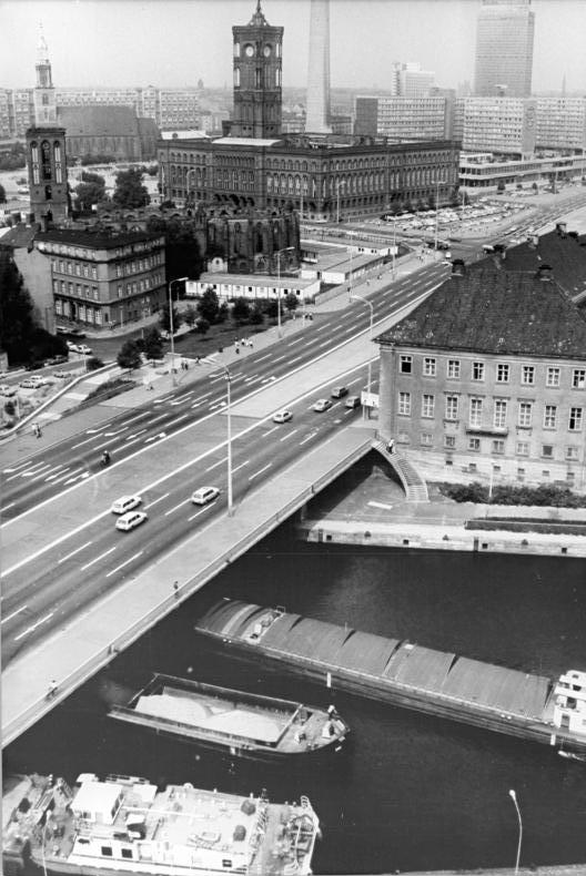 | |||||
| [P6] Bundesarchiv, Bild 183-T0913-0301 / CC-BY-SA 3.0 [CC BY-SA 3.0 de (http://creativecommons.org/licenses/by-sa/3.0/de/deed.en)], via Wikimedia Commons |
 | |
| [P7] The bridge in present times. Attribution: http://brueckenweb.de http://www.brueckenweb.de/2content/datenbank/bruecken/3brueckenblatt.php?bas=2575 |
Short facts about the bridge of today:
Type and Material: Pretensioned concrete girder bridge
Length: 114,2m
Width: 45,2m
Spans: 3
No comments:
Post a Comment